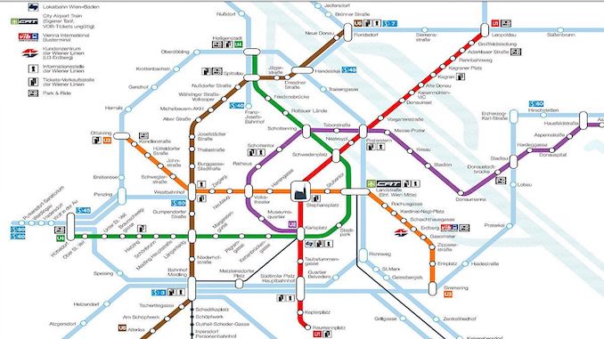
The Vienna Underground is the name of the fast public transport network in the Austrian capital Vienna, with a total length of 78,4 km. The five-line metro network is mostly underground. Only U6 and the middle part of U1 are level crossings from Krieau to Seestadt of U2.
The first part of the modern metro network was launched in 1976. However, the U4 and U6 lines were first introduced in 1898. The metro network is integrated into the Vienna S-Bahn system. This means that all trams, buses and railways in Vienna use the same ticket. Station names usually come from street or neighborhood names, or from buildings known to be nearby. However, the metro lines do not have special names. The U-Bahn word with the prefix U lines as U1 and U2.
Vienna Underground U1 and U2 Stations
Leopoldau
Großfeldsiedlung
Aderklaaer Straße
Rennbahnweg
Kagraner Platz
Kagran
Alte Donau
Kaisermühlen
Donauinsel
Vorgartenstraße
Praterstern
Nestroyplatz
Schwedenplatz
Stephansplatz
Karlsplatz
Taubstummengasse
Südtiroler Platz-Hauptbahnhof
Keplerplatz
Reumannplatz
Stadium
Krieau
Messe-Prater
Praterstern
Taborstraße
Schottenring
Town hall
Volkstheater
Museumsquartier
Karlsplatz
Austria Vienna Metro Map
Metro Map of Vienna_2020 (pdf)
Vienna Underground Ticket Fees
Vienna has a well-developed public transport network. Buses, trains, trams and metro lines take you almost anywhere in the city. Vienna public transport Wiener Linien operates five metro lines, the 29 tram and the 24 bus line, which includes the 127 night line. The night lines only operate between 0,30 to 5: 00. On weekends and public holidays, the Vienna underground stays at the service of its passengers all night. The Wiener Linien fleet currently consists of more than 500 trams and more than 450 buses.
A single ticket costs EUR 2,40.
Be the first to comment