Hamburg subway (German: Hamburg U-Bahn) Underground station in Germany's Hamburg, Norderstedt and Ahrensburg districts. The first line was opened in 1912. Line 4 serves with 91 stations. Germany – Hamburg Metro-Tram Lines and Route Maps Hamburg is Germany's second largest city and forms a separate state of its own. It is also the 6th largest metropolis in the European Union. Also called Germany's gateway to the world, the city also has Germany's largest port. It is the second largest port in Europe after Rotterdam and ranks 9th in the world.
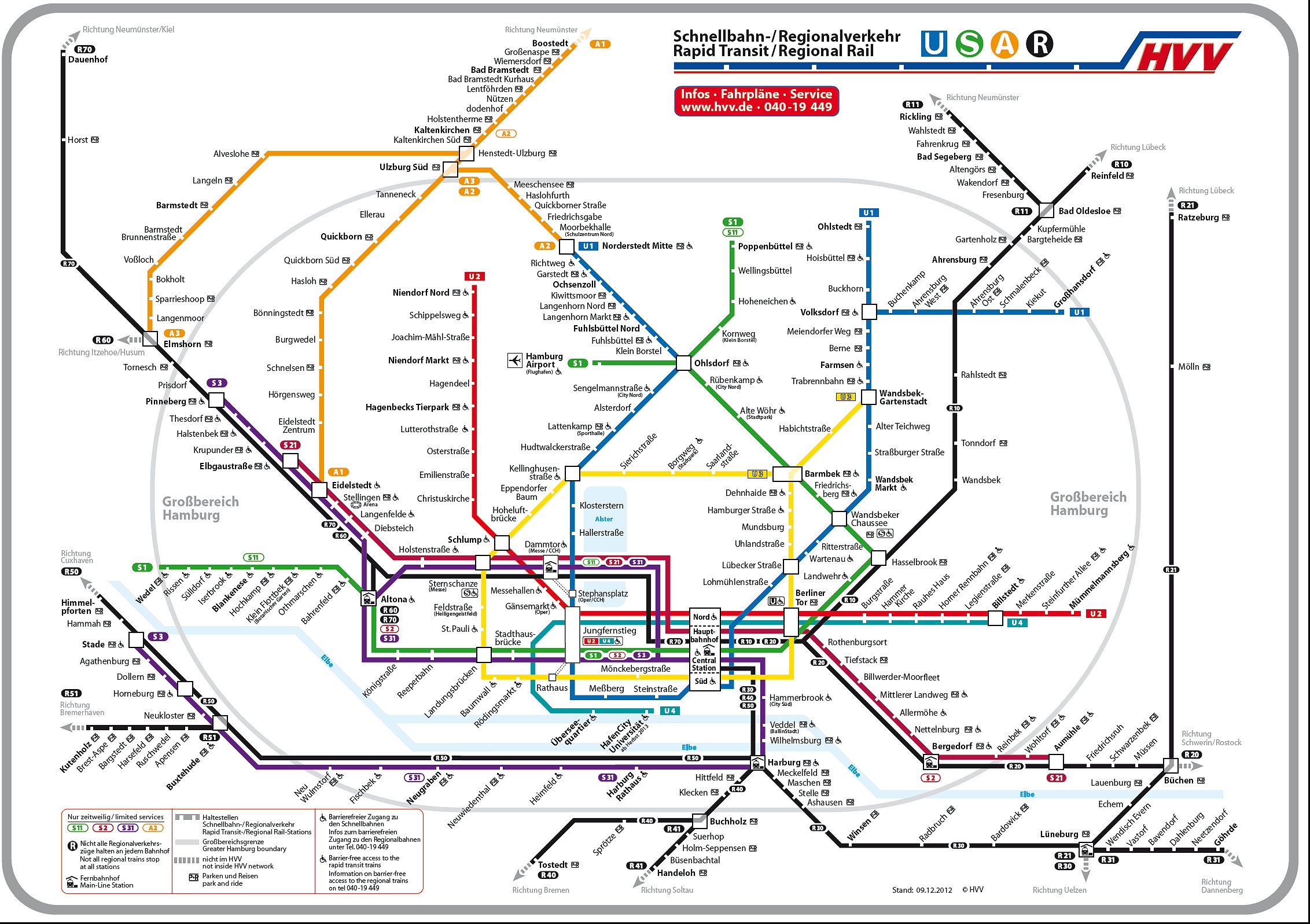
The map update for the Hamburg city metro/tram map is on the picture.
The map is for informational purposes only. If you want to see the map in large size and high resolution, either click on it or right click and save it to your computer.

U1 Norderstedt Mitte – Jungfernstieg – Hauptbahnhof Süd – Ohlstedt / Großhansdorf
- Langenhorner Bahn Norderstedt Mitte – Richtweg – Garstedt – Ochsenzoll – Kiwittsmoor – Langenhorn Nord – Langenhorn Markt – Fuhlsbüttel Nord – Fuhlsbüttel – Klein Borstel – Ohlsdorf (S1, S11)
- Ohlsdorf branch Ohlsdorf – Sengelmannstraße – Alsterdorf – Lattenkamp – Hudtwalckerstraße – Kellinghusenstraße (U3)
- KellJung-Linie Kellinghusenstraße – Klosterstern – Hallerstraße – Stephansplatz – Jungfernstieg (U2, U4, S1, S2, S3, Alster ferries)
- Meßberglinie Jungfernstieg – Meßberg – Steinstraße – Hauptbahnhof Süd (U3, S1, S11, S2, S21, S3, S31)
- Wandsbek extension Hauptbahnhof Süd – Lohmühlenstraße – Lübecker Straße (U3) – Wartenau – Ritterstraße – Wandsbeker Chaussee (S1, S11) – Wandsbek Markt – Straßburger Straße – Alter Teichweg – Wandsbek-Gartenstadt (U3)
Walddörferbahn Wandsbek-Gartenstadt – Trabrennbahn – Farmsen – Berne – Meiendorfer Weg – Volksdorf - Volksdorf – Buckhorn – Hoisbüttel – Ohlstedt
- Volksdorf – Buchenkamp – Ahrensburg West – Ahrensburg Ost – Schmalenbeck – Kiekut – Großhansdorf
Opening: 1914 total length: 55.8 km Number of stations: 46
U2 Niendorf Nord – Jungfernstieg – Hauptbahnhof Nord – Mümmelmannsberg
- Niendorf extension Niendorf Nord – Schippelsweg – Joachim-Mahl-Straße – Niendorf Markt – Hagendeel – Hagenbecks Tierpark
Eimsbüttel branch Hagenbecks Tierpark – Lutterothstraße – Osterstraße – Emilienstraße – Christuskirche – Schlump (U3) - Diameter route Schlump – Messehallen – Gänsemarkt – Jungfernstieg (U1, U4, S1, S2, S3, Alster ferries) – Hauptbahnhof Nord (U4, S1, S11, S2, S21, S3, S31) – Berliner Tor (U3, U4, S1) , S11, S2, S21)
- Billstedt branch Berliner Tor – Burgstraße – Hammer Kirche – Rauhes Haus – Horner Rennbahn – Legienstraße – Billstedt – Merkenstraße – Steinfurther Allee – Mümmelmannsberg
Opening: 1913 total length: 24.3 km Number of stations: 25
U3 Barmbek – Circle – Barmbek – Wandsbek-Gartenstadt DT3, DT5 Ring
- (Circle Line) Barmbek (U3, S1, S11) – Saarlandstraße – Borgweg – Sierichstraße – Kellinghusenstraße (U1) – Eppendorfer Baum – Hoheluftbrücke – Schlump (U2) – Sternschanze (S11, S21, S31) – Feldstraße – St. Pauli – Landungsbrücken (S1, S2, S3, Elbe ferries) – Baumwall – Rödingsmarkt – Rathaus (Jungfernstieg: U1, U2, U4, S1, S2, S3) – Mönckebergstraße – Hauptbahnhof Süd (U1, S1, S11, S2, S21, S3, Sü Berlin) becker Straße (U31) – Uhlandstraße – Mundsburg – Hamburger Straße – Dehnhaide – Barmbek (U2, S4, S1)
- Walddörferbahn Barmbek – Habichtstraße – Wandsbek-Gartenstadt (U1)
Opening: 1912 and total length 20.6 km and number of stations: 15
U4 HafenCity Universität – Jungfernstieg – Hauptbahnhof Nord – Billstedt
- HafenCity Bahn HafenCity Universität – Überseequartier – Jungfernstieg (U1, U2, S1, S2, S3)
- Diameter route Jungfernstieg – Hauptbahnhof Nord (U2, S1, S11, S2, S21, S3, S31)
- Billstedt branch Hauptbahnhof Nord – Berliner Tor (U2, U3, S1, S11, S2, S21) – Burgstraße – Hammer Kirche – Rauhes Haus – Horner Rennbahn – Legienstraße – Billstedt
U-Rothenburgsorter Hochbahn
Opening: 2012 total, length: 12.2 km and number of stations: 11
U-Bahn that is closed
It was destroyed and closed during the Second World War (2).
Hauptbahnhof Süd (U1, U3, S1, S11, S2, S21, S3, S31) – Spaldingstraße – Süderstraße – Brückenstraße – Rothenburgsort (S2, S21)
Be the first to comment