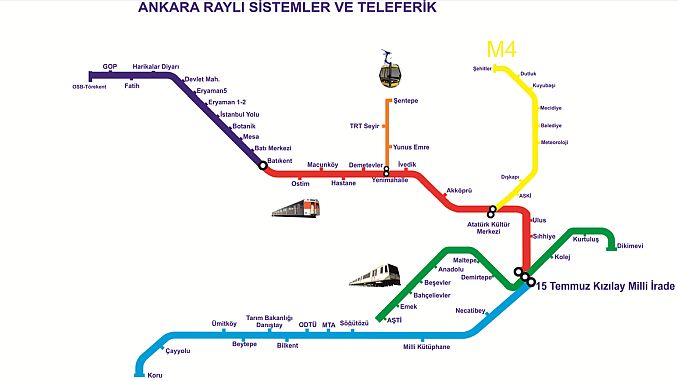
Ankara Metro Line Stations and Rail Map: public transport service in Ankara, capital of Turkey, which Ankara Metropolitan Municipality General Directorate of EGO rail transport network. The existing Ankara rail transportation network consists of light rail systems, subway, ropeway and suburban systems, and public transport vehicles operated by EGO consist of four parts:
Ay Light rail system açılan which was commissioned on August 30 on the route of Dikimevi - AŞTİ under the name of Ankaray, 1996,
28 in December 1997 on the Kızılay - Batıkent route under the name of Ankara Metro.
12 February 2014 on Batıkent - OSB-Törekent line and a month later;
13 On March 2014, the Red Crescent - Protect line was opened for service. There are a total of 45 stations between Kizilay which is the transfer station between Ankaray and Ankara metro system.
Ankaray 8,527 km. Ankara Subway M1 16,661 km. + M2 16,590 km + M3 15,360 km length of this four-rail transportation system, the total 55,140 km. long.
In Ankara Metro, the Keçiören line is still under construction. In addition, a new line construction is planned between Esenboğa Airport and Kızılay.
Be the first to comment